

High-Precision Navigation: The Future Is Near
Of all space technologies, satellite navigation is the one our economy relies on most—and its market is projected to reach €580 billion by 2033.


Issue: 127. Subscribers: 57,702.
As in all high-tech industries, navigation thrives on constant development: new services and opportunities appear thanks to satellite systems. One of the most promising is high-precision navigation. Today, conventional GNSS (Global Navigation Satellite System) satellites determine position with an accuracy of a few meters. This is no longer satisfactory for many tasks: agriculture requires precise tractor driving and fertilizer dosing, construction requires millimeter accuracy, and unmanned systems and mining equipment need perfect trajectory repeatability. New solutions deliver centimeter (and sometimes millimeter) accuracy, and the demand for such technologies is growing rapidly. In this article, we will take a closer look at the principles of high-precision positioning systems and the basics of their application.

Space Ambition provides consultancy services for stakeholders in the SpaceTech and DeepTech sectors. Whether you're an investor, corporation, aerospace agency, accelerator, incubator, ecosystem builder, startup founder, or planning to launch a SpaceTech or DeepTech business, we can help.
Contact us at denis@spaceambition.org—we’d be happy to assist. By the way Denis has a master’s degree in the industrial application for satellite navigation. Good luck with your future endeavors!
The global GNSS downstream market revenues, generated by both the device sales and the added-value services they support will enjoy a growing trend, from €260 billion in 2023 to around €580 billion in 2033. The market for the devices, expected to grow from around €70 billion in 2023 to almost €120 billion in 2033, will progressively become more mature in the long term, while the added-value service market will experience rapid growth thanks to continuous innovation: revenues are foreseen to soar from around €190 billion in 2023 to more than €460 billion in 2033.
This is precisely the cost of the navigation services themselves, not the markets they enable. For example, Uber is nowhere without navigation. In fact, every one of us uses it every day. Satellite navigation is one of the segments of space technology on which the current economy is most dependent compared to other space technologies.
The growth in demand for high-precision GNSS (~1 cm precision) systems is caused by several complementary factors:
Automation and robotization of processes. Automated machines (tractors, excavators, drones) are coming in wherever humans used to work - and they need centimeter-order precision to move safely, optimally. Agriculture, construction, and urban infrastructure are moving to digital models of a field, quarry, or facility: without high-resolution end-to-end georeferencing, integration of IoT sensors, CAD drawings, and BIM is simply not possible.
Falling cost of equipment and availability of services. Low-cost multi-frequency receivers and cloud-based navigation data correction subscriptions have become available, making the technology affordable even for small companies and startups. Moreover, there are now quite a lot of base stations in Europe and the USA, which makes it easier to connect to high-precision navigation systems.
Active development of ultra-low latency infrastructure (5G/6G). The emergence of networks with millisecond delays and wide transmission channels makes it possible to “pump out” correction data for navigation systems in real time.
Together, these drivers are forming a sustainable trend: equipment and service providers are developing increasingly flexible and scalable solutions, and customers are willing to invest in technologies that pay for themselves immediately through fuel savings, increased productivity and improved safety.
How Does the Navigation Work?
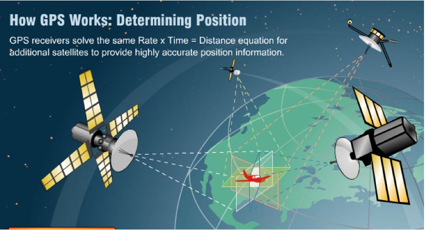
Navigation based on satellite systems (GNSS) works on a simple principle - trilateration. Each navigation satellite continuously transmits radio signals with its own unique code and precise sending time (generated by a high-precision clock on board). The GPS navigator on your phone simultaneously picks up signals from several satellites (usually, at least four).
For each signal, it compares its reception time to the encoded send time and calculates the signal transit time Δt. Multiplying Δt by the speed of radio wave propagation (practically the speed of light c), the receiver obtains the approximate distance to each satellite. The known coordinates of the satellites and the calculated “distances” allow the receiver to determine its position in space (𝑥, 𝑦, 𝑧). Since the receiver's clock is less accurate than the atomic clocks on satellites, a fourth dimension, the receiver's time offset, is included in the calculation.
Signals from four or more satellites can simultaneously refine the coordinates and adjust the receiver's internal timer. As a result, the receiver receives its position (latitude, longitude, and altitude) with the specified accuracy and can transmit it to navigation applications. The more satellites your receiver sees, the more accurate your position is.
The technology is well established, and there are several major navigation systems:
GPS (Global Positioning System) - the first and most widespread GNSS system, operated by the US Air Force, with 31 satellites.
GLONASS - Russian system, developed by Roscosmos - 26 satellites.
Galileo - European civilian system, built by the European Space Agency and EUSPA - 27 satellites.
BeiDou - Chinese global system, managed by the National Navigation Administration of China - 35 satellites.
There are also local navigation systems that improve the accuracy of navigation in a particular area:
QZSS (Quasi-Zenith Satellite System) - Japanese regional system for Asia-Oceania, complementing GPS - 4 satellites.
NavIC (IRNSS) - Indian regional system for India and surrounding areas, developed by ISRO - 7 satellites.
GPS satellites orbit the Earth at an altitude of approximately 20,000 kilometers and make two complete revolutions every 24 hours.

This basic principle of trilateration allows accuracy down to a few meters. Modern GNSS receivers face several sources of error:
Ionospheric and tropospheric delays. Radio signals are slowed and refracted as they pass through the layers of the atmosphere: the ionosphere and the troposphere. Without compensation, this leads to errors of up to several meters. However, up to a certain degree of precision, they can be counted mathematically.
Clock errors. Satellites use atomic clocks, and receivers use less stable quartz clocks. The difference in time translates into range error and subsequent position errors.
Orbital (ephemeris) errors. The exact parameters of satellite position at the moment of transmission are calculated on Earth and transmitted to the receiver with a delay; their inaccuracies entail errors up to tens of centimeters.
How Does One Get High Precision?
Depending on the task, one or another system may allows for greater accuracy than another.
1 - DGNSS (Differential GNSS).
DGNSS is a way to “tweak” a regular GPS to reduce the error from several meters to about one meter. It uses a ground-based station with “reference” coordinates - you place the receiver at a known point, and it constantly measures how much its reading differs from the true reading (error). The base station sends this difference (correction) to your receiver in real time. Your receiver receives and adds (or subtracts) this correction to its measurement, resulting in more accurate coordinates.
Analogy: Imagine walking blindly across a room and counting your steps to see where you ended up. Pure GPS is like counting your steps without taking into account that you've veered off slightly. And DGNSS is like a friend standing in the center of the room and telling you over the walkie-talkie, “You've veered off a step and a half to the right - correct your route.” As a result, you understand your position more accurately.
DGNSS features:
~0.5-1 meter accuracy;
simplicity: only one nearby base station or satellite is needed;
low cost of equipment;
accuracy of 1 m for users in the range of a few tens of km from the reference station, growing at the rate of 1 m per 150 km of separation.

2 - RTK (Real-Time Kinematic)
RTK is a method of high-precision positioning, which “pumps up” a conventional GPS receiver to centimeter accuracy. Similar to DGNSS, a rover base station is set up at a known point, receives satellite signals, and measures not only the code (as in DGNSS) but also the phase of the carrier wave. This additional data forms the double difference corrections, which remove most of the common errors (atmosphere, clock).
Analogy: Imagine two identical persons equipped with a pedometer on a known trail. Both persons count their steps, but the rover person hears: “Your step is the same as my step + 0.2 steps forward” - and immediately corrects its position with the accuracy of a “fraction of a step”.
RTK features:
Centimeter accuracy (1-3 cm) almost instantaneously.
Simple concept: one base station, direct communication.
Range: Base station should be within ~10-20 km (to maintain accuracy of corrections).

3 - Network RTK.
RTK modification - Network RTK. When a whole network of stations is operating. Several reference stations with precisely known coordinates are installed in a region (city, region, country). They continuously collect phase and code measurements from satellites.
Network RTK features:
Stability: less dependence on remoteness.
The need for a network and its support in your area.
Network RTK is ideal for tasks in large coverage areas - urban construction, infrastructure projects, agriculture over large areas, and any application where a combination of centimeter accuracy and mobility is important.
4 - PPP (Precise Point Positioning)
PPP is a method of autonomous high-precision positioning in which the receiver itself processes globally accurate satellite orbit and clock data without local base stations.
How it works: The receiver receives global files of precise satellite positions and satellite clocks published by services like IGS via the Internet (or built-in communication channel). From the data received, the receiver calculates the necessary corrections to improve accuracy.
The system gradually refines its position: for the first minutes, the accuracy may be tens to hundreds of centimeters, after convergence (10-30 min), the centimeter level is reached.
Analogy: Imagine that you set off on a journey with a map of the world on which the exact routes are marked in advance, rather than relying on landmarks along the way. At first you are slow to check your position, but soon, after studying the map, you begin to orient yourself almost instantly and with high accuracy.
PPP features:
Global coverage: works anywhere in the world without ground stations.
Accuracy: 2-5 cm after convergence.
Long convergence: takes 10-30 min to get an accurate result.

Precise Point Positioning principle. Source: NovAtel.

5 - PPP+ (Precise Point Positioning Plus)
PPP+ is an accelerated and more accurate version of classical PPP, where phase corrections are added to the global ephemeris and the receiver converges faster.
Due to phase corrections, instead of 10-30 minutes as in pure PPP, the exact position appears in 5-10 minutes.
PPP+ features:
Speed: convergence time 5-10 min.
Accuracy: 1-2 cm after convergence.
Global coverage: works anywhere in the world as long as there is a connection.
6 - PPP-RTK (Precise Point Positioning Real-Time Kinematic)
PPP-RTK is a hybrid method that combines globally accurate PPP data and local RTK corrections for ultra-fast and ultra-accurate navigation.
The receiver simultaneously uses global ephemeris error models and local phase corrections, building double-difference comparisons. Thanks to additional local data and global models, the system “captures” entire ambiguities in a few seconds and gives accuracy up to 1 cm at any point of coverage.
PPP-RTK features:
Fast convergence: seconds (as opposed to minutes for PPP and PPP+).
Centimeter accuracy: ~1 cm.
Wide coverage: combines the global coverage of PPP with the local reliability of RTK.
Complex infrastructure: requires both global ephemeris services and a network of ground stations.
High cost: subscription to two types of corrections at once.
7 - Multi-GNSS and multi-frequency
This approach receives signals simultaneously from all available constellations (GPS, GLONASS, Galileo, BeiDou, etc.) on multiple frequencies, which improves geometry and immunity to interference.
8 - Fusion with inertial and other sensors (Sensor Fusion)
The system combines GNSS data, lidar, or VSLAM (visual tracking) to smooth in “failed” areas (urban canyons, tunnels) and improve lateral accuracy.
Each of these methods and services fits different scenarios: from low-cost DGNSS solutions to highly reliable hybrid systems for autonomous vehicles and heavy machinery. The choice depends on accuracy, convergence time, coverage, and cost requirements. In the next article, we will describe the application areas of the different techniques.

How To Implement High Precision GNSS?
Regardless of the application - be it marine navigation, unmanned aerial or ground vehicles, drones or robots - the high-precision navigation service includes five key elements:
Custom equipment. Autonomous tractors, drones or other moving platforms equipped with autopilot, actuators or controllers are all needed to move the platform precisely to a given point.
GNSS receiver. A specialized receiver receives satellite signals and calculates precise coordinates using correction data.
Data transmission channel. The corrections must be received from the base station in real time. This can be cellular networks (2G/3G/4G/5G), UHF radio channels, L-band satellite channel, satellite Internet, etc. The receiver can use a network of GNSS base stations.
Network of GNSS base stations (CORS). Their data serve as the basis for the correction system and are the foundation of any real-time service.
Software for correction generation. This is where the main “magic” happens: real-time data from CORS are processed, corrections are generated (RTK, Network RTK, PPP, PPP+, etc.), which are then transmitted to the user equipment via the selected communication channel. Such software solutions are developed, in particular, by Geo++ and Cors2net, which provide algorithms for precise positioning services.
Trends
High-precision positioning technologies will become even more affordable, reliable and faster in the coming years. One of the key areas of growth will be the integration of GNSS with artificial intelligence and machine learning technologies. Already today, such approaches are used for failure prediction, adaptive filtering of multipath signals, and automatic equipment calibration. In the future, AI will be able to “learn” from terrain-specific error patterns and provide consistently high accuracy even in challenging environments such as cities or mountainous terrain.
Interestingly, regulatory initiatives and safety requirements are driving the development of the next generation of navigation systems (LEO-PNT). Laws on autopilots and ADAS (EU, USA, China) increasingly require guaranteed navigation accuracy - without centimeter corrections, full-fledged automation is out of the question.
On the other hand, the deployment of 5G, and later 6G, creates an infrastructure for low-latency, high-reliability corrections. This is especially important for autonomous vehicles and industrial solutions where “real-time” operation is critical. Moreover, the combined use of GNSS and 5G enables hybrid navigation solutions that complement each other in areas of poor satellite reception (e.g. urban canyons or indoors).
The Future Of Navigation - LEO-PNT
LEO-PNT (Low Earth Orbit Positioning, Navigation and Timing) is a new generation navigation system based not on classical high-orbit navigation satellites, but on low Earth orbit (LEO) satellite constellations such as Starlink, OneWeb, Kuiper, and others.
Satellites like Starlink, OneWeb, and Kuiper were originally built for space-based internet, but now they're starting to be used for navigation as well. Here's the trick: even Internet signals can be used as navigation signals if:
You know exactly when and where they were transmitted from;
You have a receiver that can process the phase, frequency, and delay time of the signal.

LEO-PNT uses satellites in low Earth orbit (LEO) that:
Transmit signals to Earth, just like regular Internet satellites.
These signals contain precise information about the time and position of the satellite.
A ground receiver (or smartphone in the future) receives signals from multiple satellites simultaneously.
By knowing the time at which the signal started and the current position of each satellite, it is possible to calculate the exact location, in the same way as GPS does.
This is exactly what they have started to do, for example:
SpaceX is testing positioning with Starlink (accuracy to 30 cm has already been achieved in experiments).
Xona Space Systems is building a LEO constellation with dedicated navigation signals.
U.S. Air Force is investigating the use of commercial internet satellites as a backup PNT system (in case of GPS failure).
LEO-PNT is a new navigation architecture where internet satellites become navigation stations as well. Thanks to this, the world will get:
ultra-fast 3D navigation with centimeter accuracy;
high reliability even in urban and indoor environments;
a backup PNT system in case of traditional GNSS failures.
It would be as if satellite Wi-Fi began not just to connect you to the Internet, but to show you exactly where you are, where you are going, and what is waiting for you around the corner.
High-precision navigation is moving beyond narrow industries to become a universal technology - part of the digital infrastructure of the future. From unmanned vehicles to smart agriculture, from infrastructure monitoring to personal navigators - wherever accuracy is needed, GNSS solutions are becoming smarter, faster, and more reliable.
Precision navigation is not just about centimeters on a screen. It's about how people are learning to navigate the world with unprecedented precision. We live in an era when a signal from a satellite flying 20,000 kilometers above the Earth can help a tractor avoid hitting an extra strip of field, a drone fly between two trees, and an unmanned car drive us home safely. This is the real future!

Great article so much infrastructure is reliant on GNSS and it looks to become more accurate and effective!
One of my studies was PNT resiliency in London with the Institute of Navigation a scary reality we learned was of spoofing attacks are becoming frequent so we are starting to see augmentations and nulls in antennas to combat this.
The Baku crash in December 25th last year was caused by this GPS spoofing frazzling the pilots safety systems.
Fortunately pilots and ATC have now adapted procedures!
See the effected areas here:
https://gpsjam.org/